Print

Printed guides

Paper built on the catalogue’s own data: appellations, vineyards, grapes, altitudes and vintage years. Free to download, no registration, no email address asked for.

Edition 2026-09

  • Sheets3
  • Sheet size50 × 70 cm

Wine maps

Three sheets, three scales.

Each card carries a detail from the sheet itself, so you can see what the paper looks like before you download.

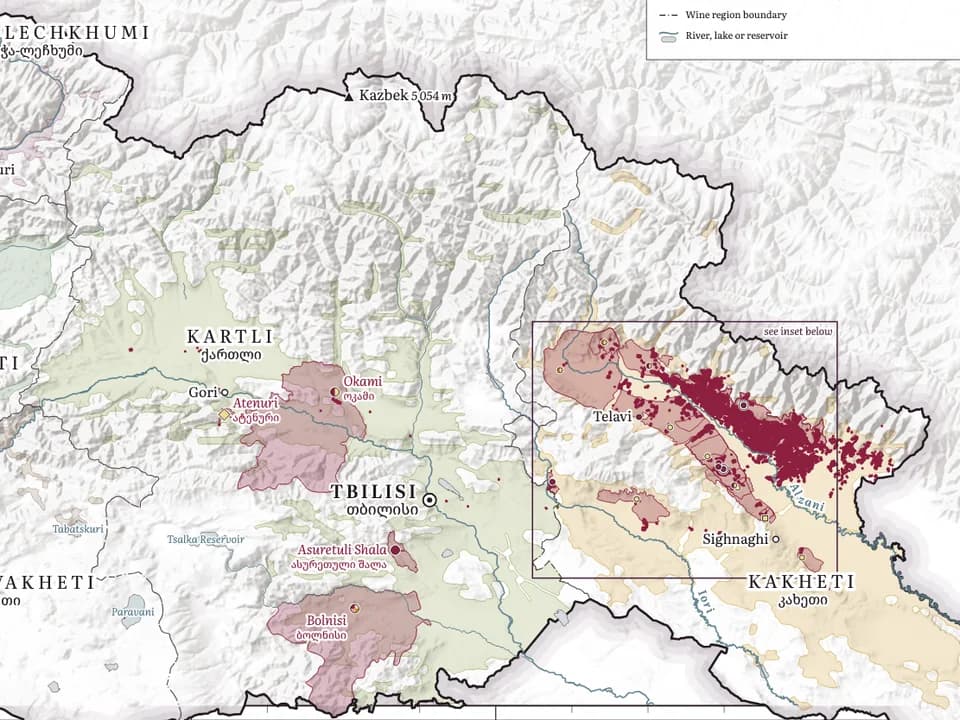
A detail from the sheet — 70 × 50 cm, landscape

Sheet
70 × 50 cm, landscape
Edition
2026-09
Print file
PDF — 23 MB

All 32 appellations with wine type and grapes, nine wine regions, vineyard parcels, rivers and vintages. Landscape sheet, 70×50 cm.

On the sheet

  • All 32 appellations in one register: region, wine type, grapes and vineyard altitude
  • Appellation zones — 28 of the 32 traced from the maps in their specifications
  • Nine wine regions with their hectares and leading grapes
  • Vineyard parcels: 16.3 of 49.9 thousand ha outlined; Kvareli and Lagodekhi surveyed plot by plot
  • Kakheti inset with 19 of its 20 zones
  • Rivers, lakes and reservoirs
  • Vintages 2016–2025 by region, each year against the region’s previous ten
  • No winery index — the wineries are on the Kakheti and Western Georgia sheets

Compiled from

  • Vineyard parcels — Ministry of Agriculture survey (Kvareli, Lagodekhi), OpenStreetMap (ODbL)
  • Appellations — Sakpatenti register; zones — maps in their specifications
  • Winegrowing zones — after the Georgian Wine Club regional sheets
  • Hectares, grapes — Vineyard Cadastre 2025
  • Region outlines, rivers, lakes — OpenStreetMap
  • Vintages — ERA5-Land and ERA5, Copernicus Climate Change Service (CC BY 4.0)
  • Relief — SRTM via Terrain Tiles

A detail from the sheet — 50 × 70 cm, portrait

Sheet
50 × 70 cm, portrait
Edition
2026-09
Print file
PDF — 10 MB

The core of the Alazani valley: 20 appellations with their approximate extent by the villages named in the specifications, an index of catalogue wineries, vineyard altitudes, grapes and vintages.

On the sheet

  • 20 appellations with wine type, grapes and vineyard altitude from their specifications
  • Zones from the maps in their specifications; where there is none, the approximate extent by the villages the specification names
  • Catalogue wineries, numbered, with an index — only those with a confirmed exact location
  • Vineyard parcels: 15.8 of 42.6 thousand ha outlined, 11.4 of them surveyed plot by plot
  • Kakheti in numbers: hectares, plots, vines by planting year, leading grapes
  • Municipalities, rivers and lakes
  • Vintages by zone, each year against the zone’s previous ten

Compiled from

  • Vineyard parcels — Ministry of Agriculture survey (Kvareli, Lagodekhi), OpenStreetMap
  • Rivers, lakes, villages, region outlines — OpenStreetMap (ODbL)
  • Appellation zones — maps in their specifications
  • Villages, wines, altitudes — Sakpatenti specifications
  • Hectares, grapes — Vineyard Cadastre 2025
  • Wineries — getwine.ge catalogue
  • Vintages — ERA5-Land and ERA5, Copernicus Climate Change Service (CC BY 4.0)
  • Relief — SRTM

A detail from the sheet — 50 × 70 cm, portrait

Sheet
50 × 70 cm, portrait
Edition
2026-09
Print file
PDF — 19 MB

Imereti, Racha-Lechkhumi, Samegrelo, Guria and Adjara on one sheet: eight appellations, insets of the Rioni valley and the Imeretian core, catalogue wineries.

On the sheet

  • Eight appellations with wine type, grapes and vineyard altitude
  • Insets: the Rioni valley, with five of the eight appellations, and the Imeretian core from Baghdati to Zestaponi
  • Zones from the maps in their specifications; Obcha, Racha and Lechkhumi by the villages they name
  • Catalogue wineries with an index — only those with a confirmed exact location
  • Five wine regions with their hectares and leading grapes
  • Vineyard parcels: 0.2 of 4.2 thousand ha hand-drawn in OpenStreetMap; empty means unmapped
  • Rivers, lakes and reservoirs
  • Vintages by appellation, each year against its previous ten

Compiled from

  • Vineyard parcels, rivers, lakes, villages, region outlines — OpenStreetMap (ODbL)
  • Appellation zones — maps in their specifications
  • Khvanchkara boundary, Racha vine area — after the Georgian Wine Club map
  • Hectares, grapes — Vineyard Cadastre 2025
  • Appellations — Sakpatenti, National Wine Agency
  • Wineries — getwine.ge catalogue
  • Vintages — ERA5-Land and ERA5, Copernicus Climate Change Service (CC BY 4.0)
  • Relief — SRTM

How a sheet is made

A printed map is a claim you cannot correct.

Paper is the one format where a mistake cannot be fixed once it is on the wall, which is why every sheet is compiled the way the site is: from named sources, with the gaps left visible.

1

Draw the zones from the specifications

Appellation zones are traced from the maps in their own specifications; the list of appellations, their wines and vineyard altitudes come from the Sakpatenti register. Region outlines, rivers and lakes are taken from OpenStreetMap and Natural Earth.

2

Plot only confirmed places

A winery goes on a sheet only if its place in the catalogue is confirmed and exact. That is a rule from the data, not a selection: a place on the map is not sold. Where numbers would crowd they are nudged apart — on the Kakheti sheet by up to 1.5 km.

3

Print the sources on the sheet

Every sheet carries the list of what it was compiled from, and the edition date. A map without its sources is decoration.

4

Leave the gaps visible

An empty patch on a sheet means nobody has outlined the vineyard yet, not that there are no vines. The legend says how many of the hectares are actually outlined — the same rule as the site.

Sources

And the same right of reply applies to paper.

Compiled from public sources and may contain errors. Each sheet prints the sources it was drawn from, and every classification on it can be disputed — the right of reply applies to a printed guide exactly as it applies to the site.

A producer named on a sheet can dispute its position or its classification exactly as on the site: a document persuades, the record is corrected on the site straight away and on paper in the next edition.

Dispute a sheet

Printing it

The home-printing version: white background, prints on any printer. A press version with a full-bleed background is prepared separately.

Free and not for sale — every sheet says so in its footer. Part of the data behind the Georgian sheets, the Vineyard Cadastre, may be used for non-commercial purposes only.